The Present
Arkansas is divided into seventy-five counties, about half of which are in the highland or mountainous region of the state. Benton county is situated in the extreme northwestern corner of the state, with McDonald and Barry counties, Missouri, adjoining it on the north, Carroll and Madison counties, Arkansas, on the east, Washington county on the south and Indian Territory on the west. Its southern boundry extends to within fifty miles of the Arkansas river to within fifty miles of the Arkansas river at Ft. Smith and its northern limits lie 174 miles directly south of Kansas City and about 315 miles by rail southwest of St. Louis. It is irregular in shape, its western portion being ten miles wider than its eastern part, and has an extreme length east and west of 42 and one-half miles, while its greatest width north and south is 28 miles. It encloses within its limits 891 square miles, or about 570,000 acres of surface.
Topography and Steams
Benton is one of the plateau counties of northwestern Arkansas. It lies on the summit and upper slopes of the Ozark range, from 1,000 to 1,800 feet above sea level. The crest of the Ozarks extends from northeast to southwest across the eastern part of the county, its probable greatest elevation being attained on the summit of Poor mountain in the northeastern part of the county, near Garfield. This crest consists, for the most part, of gently rolling prairies and, what is locally termed, flatwoods. The latter are level timbered tracts. Extending westward from the main range across the center of the county is a wide area of table land, also consisting of prairies and flatwoods; this gradually grows less in altitude as the main divide is left behind, and it finally merges into the great prairies of the Indian Territory
About four-fifths of the surface of the county was originally timbered. Nearly one-half of it consists of the table lands spoken of above, the remainder embracing the level lands that lie along the streams and in the upland valleys, and the rugged mountainous sections. The latter are simply the regions of gigantic bluffs, hills and ridges to be found from one to ten miles back from all the leading watercourses. Throughout the mountains are gorges, canyons and small valleys presenting at every turn scenes of surpassing natural beauty.
From a point a few miles east of its center, the surface of the county slopes in almost every direction, the streams that flow across its territory nearly all rising within its limits. It is one of the best watered counties in the United States, having numerous watercourses of greater or lesser volume, whose never ceasing flow is fed by myriads of sparkling springs, some of which are of remarkable size. The brooks and creeks are all rapid, typical mountain streams, and their waters are singularly pure and clea, in the deeper pools taking on a dark greenish-blue. The clean sand, gravel and rocky ledges over which they run prevent them from becoming muddy, excepting after very hard rains.
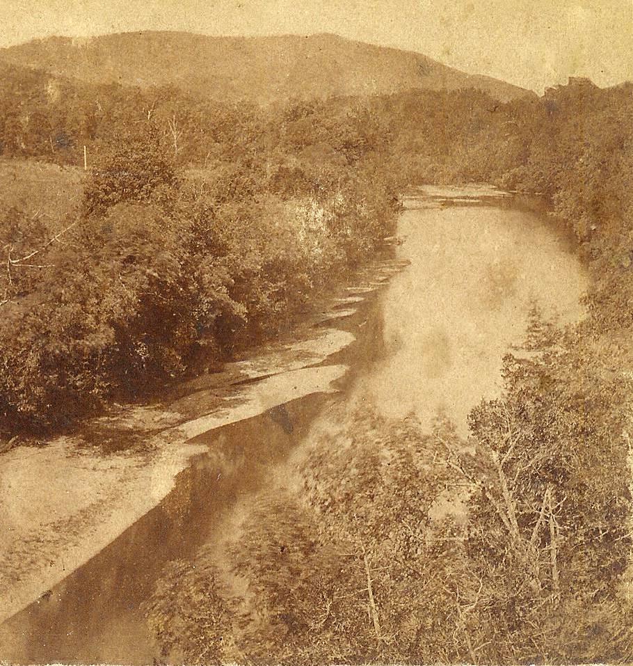
The principal watercourse of the county is White river, which drains all of that part of the county lying east of the main divide. This stream enters Benton county on its southern boundry, about eight miles west of its southeastern corner, and pursues a general northeasternly course, flowing into Carroll county and thence into Missouri, finally emptying into the Mississippi river. In its windings across the county, however, it eventually flows toward every point of the compass, and its valley is deep and narrow with numerous towering perpendicular cliffs of solid rock, affording magnificent mountain scenery at almost every point. The leading tributaries of White river in Benton county are War Eagle, Little Clifty, Prairie and Indian creeks, the first two on the east and the last two on the west side of the river.
An image from a stereoview card of the White River from the 1880s
Big and Little Sugar, Butler and Honey creeks rise in its northern half and flow to the northwest into Missouri. Spavinaw river and Flint creek head in the central western part and flow to the southwest into the Indian Territory. Osage creek rises near the center of the county and pursues a southwesterly course, emptying into the Illinois river. The last named watercourse heads into Washington county, crosses the extreme southwestern part of Benton and empties into the Arkansas river. The other streams mentioned above, excepting White river, are tributaries of Grand river and, through it, of the Arkansas. These rivers and creeks, with numerous small branches, afford ample drainage, and the finest of living water can be obtained from the springs, or can be found anywhere at reasonable depths.
Climate and Soil
Benton county possesses a climate that is agreeable and peculiarly adapted to the maturing of the various crops that can be grown in this latitude. Its winters are comparatively short and usually without excessive cold. The summers are long, and while the thermometer may at times register a higher temperature than that region farther north, the heat partakes of a dryer character and is not oppressive. The country is sufficiently elevated to produce uniformly cool and pleasant nights, with a refreshing breeze blowing. The average annual temperature is about sixty degrees. The yearly rainfall is ample for all purposes, averaging about forty inches, and is usually well distributed throughout the seasons, thus insuring freedom from drought. The snowfall is light, rarely exceeding ten to twelve inches for the entire winter. During the winter of 1900-'01 it did not exceed three inches. In February, 1902 a seven inch snow fell, the heaviest in 20 years, but it was all off in less than three days!
The soils of Benton county are extremely diversified in character. They extend to a considerable depth and range in color from black or dark red to a light gray. They are nearly everywhere thickly intermixed with limestone and flint gravel, which is constantly decomposing, thus adding materially to their productiveness. They are also very susceptible to artificial fertilizers, and whenever these are used the yield is largely increased.
The soil of the bottom lands along the watercourses and in the smaller valleys is composed of the alluvial deposits of the streams that flow through them, intermixed with the rich washings from the adjacent mountain sides, and is as productive when properly handled as any in the West. The upland valleys have deep, rich, red soil adapted to all classes of crops, while that of the hill regions is rocky and less fertile, but well suited to fruit growing and stock raising. The soil of the flatwoods and prairie districts lies smooth and is usually free from rock, generally of a sandy natuel or composed of fine gravel. The latter is especially desirable on account of its remarkable adaptability to the growth and maturity of the fruit.
Products
Probably one-third of the surface of Benton county is still covered with a heavy forest growth, consisting principally of oak, hickory, walnut, elm, ash, hackberry, sycamore, cottonwood, hard and soft maple, linden, chincapin, gum, box alder, and similar timber. There are also several extensive areas of pine. This, however, has been largely cut out, and what remains is, to a great extent, young growth.
This portion of the southwest is well adapted to the production of all the tame and wild grasses common to this latitude, and blue grass does well when properly handled. It is also located in the great fruit and grain belt of the United States. Corn and wheat are chief among the grains crops, although there are immense quantities of other grains raised. Wheat ranges from 15 to 30 bushels per acres, corn from 30 to 60 bushels, and oats from 20 to 40 bushels. Other profitable crops are sorghum, broom corn. flax and buckwheat. Hay, both clover and timothy and also alfalfa and stock peas is a large item in the output of the county, the red clover being of vigorous growth and fine quality. Potatoes, turnips, and all kinds of vegetables are produced in abundance.
Benton county being a corn, hay and grass region, and splendidly watered, it naturally follows that it would be a good stock country. Nearly every farmer does more or less rasing, feeding and shipping of cattle, hogs or sheep, and there are a few fine stock breeders in the county, but this industry is as yet practically in its infancy. Horses and mules also form no small part of its output, as does poultry of all kinds, the conditions prevailing here being particularly well suited to the raising of the latter.
In fact, the county's production of poultry and eggs has grown to be something enormous and has become the sustaining force of several large business enterprises.
Fruits
In spite of all that can be said regarding Benton county's natural and acquired resources in other directions, the fact still remains that it is pre-eminently a fruit producing region and that the income derived from its fruit is over-whelmingly the greatest force in its business life. Compared with its fruit interests, every other industry within its borders appears but a side issue. Nature here seems to have combined all of the essentials for successful fruit growing. The climate, percentage of sunshine, elevation of the country, perfect air and water drainage, and the proper soil ingredients are all here to assist in producing the finest flavored, best developed and most beautifully colored fruit in the world.
All kinds of small fruits, embracing strawberries, raspberries, cherries and plums, do exceedingly well here and the vineyards are as fruitful as any in the world. Pears also occupy an important place, but it is in apples and peaches that Benton county leads them all. In many localities the county for miles at a stretch is one vast orchard. The orchards range in size from a few acres up to hundreds, but they are, for the most part, the property of individual owners.
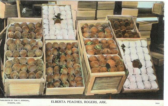
This is the home of the famous Elberta peach which has become a favorite wherever it has gone on account of its large size, rich color and exquisite flavor. The other leading varieties of peaches grown here are as follows: Late and Early Crawford, Smock, Champion, Heath, Cling, Chinese Cling, Picquette Late, Salway, Mountain Rose, Family Favorite, Old Mixon Free, Poole's Favorite, and Madison County Mammoth. The last two were originated in northwest Arkansas
Elberta Peaches ready to be shipped
The principal varieties of apples produced here are the Ben Davis, Gano, Etris, Johnathan, Maiden Blush, Winesap, Limber Twig, Arkansas Black, Mammoth Black Twig, Smith's Cider, Rome Beauty, Coffelt, Highfill, Given, Collins Red, Ingram, Missouri Pippin, Shannon, Mammoth Pippin, Rambo, and Duchess of Oldenburg.
The Etris, Coffelt, Highfill and Given were originated in Benton county, the Arkansas Black, Mammoth Black Twig, Collin's Red, and Shannon in other parts of northwest Arkansas and the Gano and Missouri Pippin in Missouri.
This table is a summary up to January 1st of this year [1903]. It was learned from authentic sources that, at that time, one-tenth was to be added to the amount of dried apples for this class of fruit not yet shipped from the county.
Springdale is located just over the line in Washington county, therefore only half of the fruit shipments from that station are shown, as those should be accredited to Benton county, having been produced here.
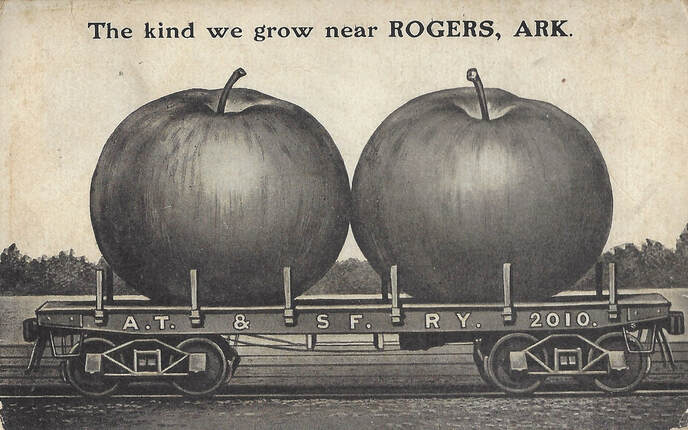
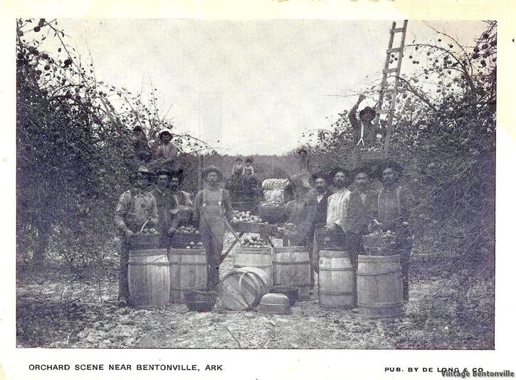
Benton is the leading apple county in the United States in the number of bearing trees, and this means that it has more apple trees than any similar extent of territory in the world. The census of 1900 gave the number of bearing trees in the county as 1.613,366 and this has been material increased during the past two years.
One of many of hundred of orchards in Benton County
Horticultural societies have been organized at Gravett, Gentry and Bentonville. The latter, known as the Benton County Horticultural Society, is the oldest. It was established in 1888 and reorganized in 1894.
These societies are composed of fruit growers, shippers, businessmen, and others who take an interest in the production of fruit. Their object is principally to disseminate knowledge concerning the propagation and growth of fruit, to stimulate original research and experimentation along these lines, and to protect both their members and public against imposition.
Fruit shippers associations are in existence at Rogers, Gravett, Gentry, and Siloam Springs. Their purpose is to facilitate the handling, shipment and sale of the fruit grown within their territory, and further the general interests of their members.
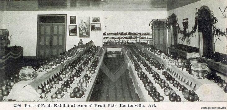
On Oct 28, 29 and 30 of last year [1902], a very successful county fruit fair was held in Bentonville, at which an exceedingly fine display of the products of this part of the state, excepting livestock, was shown. As an outgrowth of the fruit fair, there has been organized an association for the purpose of holding an annual horticultural, agricultural and mechanical county fair at Bentonville. The association is incorporated and has an authorized capital of five thousand dollars.
Early image of one of Bentonville Fruit Fairs
Minerals
Judging from surface indications and the finds that have already been made, Benton county lies in the great lead and zinc district of the southwest. The ores of both metals have been repeatedly found, and nearly every drill hole or well that is sunk produces shines. No prospecting to amount to anything has ever been done, however, consequently the extent and value of the ore bodies are unknown.
The county contains fine quarries of lime, building and sand stone, as well as large deposits of pottery, tile and brick clay and gravel and building sand are abundant. Three miles northwest of Bentonville is a deposit, in eight workable strata, of lithographic stone, pronounced by competent authorities to be the best ever discovered in America and fully equal to the imported. The beds of it here are seemingly inexhaustible.
The geological structure of the county is such that it has been productive of numerous caves. Some of these are mere caverns in the faces of the bluffs, and others consist of intricate systems of rooms and passages extending perhaps for many miles. One of the most remarkable of these is Spring Cave about five miles north of Bentonville in the hills of Little Sugar creek, which has been explored for a long distance. Further down that stream is the Crystal Cave which is noted for its beautiful crystalized formations; its entrance is on the very summit of a mountain, descending almost perpendicularly into the earth for one hundred feet and closely resembling the crater of a volcano.

