If someone asked you where Osage, Cannon, or Orchard was in Benton County, could you tell them where is was? We're going to have some fun with names and their origins in this article. Many towns either made it or not depending where the railroad came through the county or on how dependent they were on the fruit industry.
Apple Spur - was a small community that was located between Rogers and Bentonville. It had a spur off the railroad line to pick up apples. This community no longer exists.
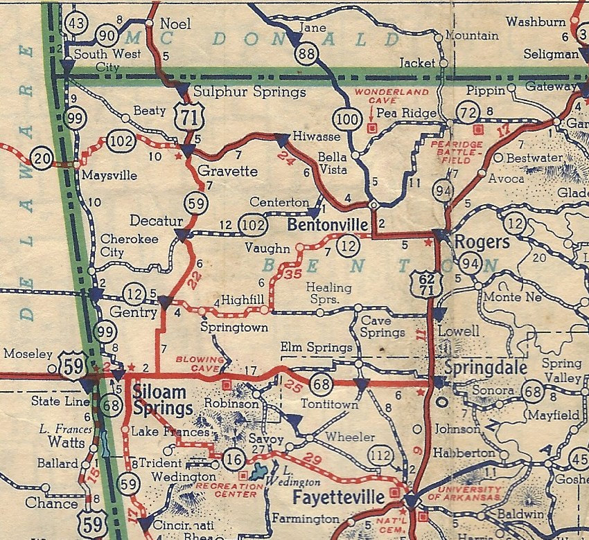
Avoca - The original location of Avoca was where Brightwater is now located. When the railroad came through in 1881 to secure a railroad depot, the community moved beside the train track and took the name Avoca with them. The name Avoca is believed to have come from an Irish poem. At one time in the early 1900s, the town thrived because of the fruit industry, but as fruit production declined so did the population of Avoca.
Beaty - was established in around 1873. The last store closed in the town in 1934. It had been a thriving community until the Great Depression, which lead to it demise. Beaty was located west of Gravette.
Bella Vista - A Presbyterian pastor, Rev. William S. Baker, was credited with giving Bella Vista its name around 1915. The name means "Beautiful View".
Bentonville - The town now known as Bentonville was originally called Osage. The Bentonville community was established as the county seat of Benton County in November of 1837, about a year after Arkansas became a state. It was named after Thomas Hart Benton, a Missouri senator who helped Arkansas become a state. Bentonville was the predominant community in Benton County until the railroad came through.
Bloomfield - This small town was established around 1873. It was about six miles north of Siloam Springs. The town lost population when the railroad didn't come through that community. Most businesses in the town picked up and moved closer to the railroad. The name of the town is believed to have come from the flowering vegetation around the town. In the early 1900s the town just faded away.
Brightwater - This community has had many names during its life. The first building in the village was built near Sugar Creek north of what would become Rogers in 1840 by Enoch Trott, and the community was originally known as Trott's Stand. Other names it has had over time are: Bucksnort, Stunner, Scud, Bestwater and Avoca. Part of this town up and moved to the where the railroad was built in 1881, taking the name Avoca with it. Most people since 1882 have known this area as being Brightwater, but from 1917 to 1939 the post office's name was Bestwater.
Cave Springs - was first settled about 1852. The original name for the area was called Cannon. In about 1902 or 1903, people started to use the name Cave Springs. When the Kansas City and Memphis railroad came through in 1906, it really helped to develop the town. In 1909, the town was platted and in 1917 it was incorporated as Cave Springs. When the railroad was taken out in 1918 and the apples were gone, the town became a small village again. This area is once again becoming a popular residential community.
Centerton - The town was originally called Centerpoint, but in 1898 the name was changed to Centerton since there was another town in Arkansas already named Centertpoint. The town started to grow when a railroad put in a line through town from Rogers to Grove, Oklahoma, and a depot and shipping yard was added. Like a lot of towns, they became a small village again when the apple industry gave out, and the rail line was taken up. Centerton has experienced a population increase in recent years due to its proximity to some major employers nearby.
Cherokee City - The village here was called Hogeye before the Civil War. In 1880, the town was platted with the intention of calling it Hogeye, but since there was already a Hogeye in Washington County, the postal service made them change their name. It was named for the Cherokee indian who lived in nearby Indian Territory. In 1915, the population of the village was shown as being 79 people. A hundred years later, the population was about the same. Cherokee City is located on the extreme western edge of Benton County.
Colville - a small village that was named after a prominent early settler. It is said that he left for California in the 1850s during the gold rush never to return. The village did have a post office from 1879 to 1904. It was located in the area near Mt. Hebron Road in southwest Rogers. This community no longer exists.
Cross Hollows - This area was named by 1843. It was named Cross Hollows because it is where two hollows intersect. It was located between Rogers and Lowell. It was a trading post and stagecoach stop prior to the Civil War. During the war it became an encampment for both armies. At other times it was also called Stony Point and Limedale.
Decatur - Previous to 1883, the town had been known as Corner Springs. In 1883, with the establishment of a post office, the name was changed to Decatur. The town was named for Stephen Decatur who was a U.S. naval hero. In 1893, the Kansas City, Pittsburg, and Gulf Railroad helped the town to grow. Around 1915, the apple industry started to die, and the town with it. Its population has increased in recent years.
Dickson - was a small town that was established around 1871. It was originally called Old Town, then was renamed on honor of Joe Daniel Dickson, an early settler.. The town went by this name until 1899 when the post office name was changed to Hiwasse.
Eldorado - The word Eldorado in Spanish means "the gilded", indicating a very rich place. The town was established as early as the 1870s. It is said that after the Civil War a couple settled beside a spring here. They found that drinking water from the spring cured their arthritis and other ailments. In the early 1880s the community became a health resort. At this time the population had reached 1500 people. Sometime in the mid 1880s, a major flood happened and the town was just about wiped out. The community never rebuilt. This community was southwest of Gravette and northwest of Decatur.
Fairmount - was originally called Georgia Flats. In 1868, the name was changed to Fairmount, because many ot the settlers had come from Fairmount, Georgia. Fairmount was located north and east of Siloam Springs.
Garfield - This community was originally known as Crowell then as Blansett. The town was platted in 1883. It was named after assassinated president James Garfield. In the 1920s and 1930s the population began to decrease but has slowly grown again over the decades.
Gateway - is a small town located on the Arkansas & Missouri border. It got its name as being the "Gateway to the Ozarks", and the gateway to Eureka Springs. The town was incorporated in 1934.
Gentry - It became a town in 1893 after the railroad was put through the western part of the county. The town was named after Richard Gentry who was the general manager of the train line. It was originally called Gentry City. When they applied for for a post office by that name the word "City" was rejected by the government. For a very brief period of time around 1897 to 1900, the town was called Orchard / Orchard City. By 1900 the name was again changed to Gentry. Since its formation, Gentry has changed very little.
Gravette - This town has had several names over time. It has been called Chalk Valley, Old Town and finally Nebo. The town of Nebo was started sometime in the 1880s. It was named after E. T. Nebo who was an early settler. It was best known for its large whiskey distillery. When the railroad came through the area, it missed Nebo. So like so many other communities, most people picked up and moved to a new town which they called Gravette, or Gravett. Gravette was named in the early 1890s after Ellis T. Gravett, an early settler. There several stories saying Mr. Gravett had a falling out with his family in Kentucky and dropped the e off the end of his name. There are also stories that the e was added to the name by a newspaper or railroad clerk and it has stayed that way.
Healing Springs - The springs at Healing Springs were thought to have curative powers. The town grew when the Arkansas, Oklahoma & Western railroad came through town. This village sat four miles west of Cave Springs. The village never grew very large, and in 1915 the railroad line was removed. In 1906 the population of the town was 106.
Hico - was established in the 1880s. The Gunter family settled this area and Nancy Ward Gunter named her home "Hico", which was the Cherokee word for "sparkling water." In 1885, the population was 119. The town was absorbed into Siloam Springs during the last century.
Highfill - Highfill was also another village that came into existence with the coming of the Arkansas, Oklahoma & Western railroad in 1906. The town was named after Hezekiah Highfill who homesteaded the area and gave the right of way for the railroad. The railroad was later taken up in 1915. Highfill is located 8 miles west of Cave Springs.
Hiwasse - This community was at different times called Old Town and Dickson. The new town of Hiwasse was established when the Frisco railroad came through the area in 1898. There are several explanations as to where the name of the town came from. One is that it is an indian word meaning "sunny spot". Other explanations are that it might have been a railroad man's alma mater, Hiwasse College, in Tennessee, or that it was named after an area of the same name where a settler came from in Tennessee.
Hoover - was at one time a small town. It was located just southeast of Highfill. The town is said to be named after Herbert Hoover who surveyed the area and later became president. The town no longer exists.
La Rue/Larue - The is a small community that we know was here in 1867. The name in French means "the street". The name might have come from a town in Kentucky from which a lot of early settlers to this area may have come. It appears that the town has gone by either spelling.
Leestown - was an area that was settled in the 1840s. It was a thriving little community before the Civil War but found itself in the middle of the Battle of Pea Ridge. There are no longer any buildings left in Leestown, and it sits within Pea Ridge National Battlefield.
Little Flock - The community formed around the Little Flock Primitive Baptist Church organized in 1843. The name comes from Luke 12:32 "Fear not, little flock, for it is your Father's good pleasure to give you the Kingdom". The town was incorporated in 1970 with a population at that time of 403.
Logan - is a small community that is approximately 4 mile southeast of Springtown and 4 miles southwest of Highfill. This was once a thriving community named after a local settler.
Lowell - The original community, located a mile east of present-day Lowell, was originally called Bloomington or Mudtown. Apparently Mudtown was appropriately named. When the Frisco railroad came through in 1881, it missed Mudtown by a little and a new town called Lowell was established along the railroad. The town was incorporated in 1905.
Mason Valley - was settled in 1856. A post office was established in 1883. The town was named after the Mason family who settled in this area. It was located just northwest of the Northwest Arkansas National Airport.
Maysville - is the oldest community in Benton County, having been established in the 1840s. It was a thriving community until the Civil War and is said to at one time have been larger than Bentonville. The Civil War did its damage to the town with a battle in Maysville. Then in 1891 there was a fire that destroyed most businesses in town. Since the railroad didn't come through town, the community never grew very big. It is located on the Oklahoma border west of Gravette.
Monte Ne - This little community has had several names: Silver Springs Mill, Silver Springs, Pettigrew Mills, Vinda and, of course, Monte Ne for the last 120 years. This town was developed as a resort beginning in 1900 and 1901 by William Hope "Coin" Harvey. Mr. Harvey also ran for president of the United States in 1932 holding his convention at Monte Ne. The name Monte Ne is from the Spanish word meaning mountain and an Indian word for water, thus the meaning "mountain water". The resort was incorporated in 1913, and the corporation was dissolved in 1928. Part of the Monte Ne resort now lies under Beaver Lake which was filled in the 1960s, with the rest lying in ruins along the shore line. A small residential community still exists on the shoreline of the lake..
Osage Mills - was given its name because it was the site of a grist mill located on Osage Creek. The mill was established around 1839. The name of the community is believed to have been given by the area's first postmaster, John Smith. The small town was located between the present-day Northwest Arkansas National Airport and Cave Springs.
Pea Ridge - One explanation for the name is that when the early settlers arrived the area, there were pea vines which covered the ridge that was first settled, thereby making Pea Vine Ridge an appropriate description. At the time of the Civil War, the "Vine" was dropped to make it Pea Ridge. The first post office was established here in 1850. Apparently in 1889 when Goodspeed's History of Benton County was written, the town wasn't large enough to be mentioned. By 1915, the population of the town had grown to 105 people.
Rogers - The town was laid out in March of 1881 and started to grow with the arrival of the first first train on May 10th of that year. The town itself wasn't incorporated until June 6th, 1881. The town was named in honor of Capt. Charles W. Rogers who was the general manager of the railroad. It is said that there was much discussion over the name before it was decided. The town grew quickly, being right on the railroad line. Within a short period of time a spur off this line was built to connect Bentonville.
Siloam Springs - The area where Siloam Springs is located was originally called Old Mayfield Springs, which later became the community of Hico, then Siloam City, then finally Siloam Springs. This area was first settled in the 1840s. By 1879 it was believed that some of the springs there had medicinal value and would make a good health resort. By 1880 the town was laid out in plats centered around a large spring. This spring was called Siloam after the biblical pool by the same name in Jerusalem. In 1881, the population was over 2000 people. The name was changed in 1886 from Hico to Siloam Springs. By the 1970 census, the population was around 7000 people.
Springtown - was first called Old Hickory. The town was laid out and surveyed in 1870 and the name changed to Springtown, named so because a large spring in town. It is said that when they were picking a town name, everyone put their choice fora name in a hat and had a child pull out the name, and that became the name of the town. Springtown is along Highway 12 between Highfill and Gentry.
Sulphur Springs - The town was laid out in 1878 by Charles H. Hibler and was named after the six sulphur springs located in town. Like most towns with good springs in the area, the water was believed to have a medicinal value. When the railroad came through in 1890, the town became a popular resort destination. It is located in the northwest corner of the county.
Vaughn - was established in 1895, probably named after a family who settled the area. It is located southwest of Bentonville.
Compiled from a variety of sources, including a 1978 University of Arkansas dissertation by Cheryl Barnwell Fenno entitled The Place Names of Benton County, Arkansas
Apple Spur - was a small community that was located between Rogers and Bentonville. It had a spur off the railroad line to pick up apples. This community no longer exists.
Avoca - The original location of Avoca was where Brightwater is now located. When the railroad came through in 1881 to secure a railroad depot, the community moved beside the train track and took the name Avoca with them. The name Avoca is believed to have come from an Irish poem. At one time in the early 1900s, the town thrived because of the fruit industry, but as fruit production declined so did the population of Avoca.
Beaty - was established in around 1873. The last store closed in the town in 1934. It had been a thriving community until the Great Depression, which lead to it demise. Beaty was located west of Gravette.
Bella Vista - A Presbyterian pastor, Rev. William S. Baker, was credited with giving Bella Vista its name around 1915. The name means "Beautiful View".
Bentonville - The town now known as Bentonville was originally called Osage. The Bentonville community was established as the county seat of Benton County in November of 1837, about a year after Arkansas became a state. It was named after Thomas Hart Benton, a Missouri senator who helped Arkansas become a state. Bentonville was the predominant community in Benton County until the railroad came through.
Bloomfield - This small town was established around 1873. It was about six miles north of Siloam Springs. The town lost population when the railroad didn't come through that community. Most businesses in the town picked up and moved closer to the railroad. The name of the town is believed to have come from the flowering vegetation around the town. In the early 1900s the town just faded away.
Brightwater - This community has had many names during its life. The first building in the village was built near Sugar Creek north of what would become Rogers in 1840 by Enoch Trott, and the community was originally known as Trott's Stand. Other names it has had over time are: Bucksnort, Stunner, Scud, Bestwater and Avoca. Part of this town up and moved to the where the railroad was built in 1881, taking the name Avoca with it. Most people since 1882 have known this area as being Brightwater, but from 1917 to 1939 the post office's name was Bestwater.
Cave Springs - was first settled about 1852. The original name for the area was called Cannon. In about 1902 or 1903, people started to use the name Cave Springs. When the Kansas City and Memphis railroad came through in 1906, it really helped to develop the town. In 1909, the town was platted and in 1917 it was incorporated as Cave Springs. When the railroad was taken out in 1918 and the apples were gone, the town became a small village again. This area is once again becoming a popular residential community.
Centerton - The town was originally called Centerpoint, but in 1898 the name was changed to Centerton since there was another town in Arkansas already named Centertpoint. The town started to grow when a railroad put in a line through town from Rogers to Grove, Oklahoma, and a depot and shipping yard was added. Like a lot of towns, they became a small village again when the apple industry gave out, and the rail line was taken up. Centerton has experienced a population increase in recent years due to its proximity to some major employers nearby.
Cherokee City - The village here was called Hogeye before the Civil War. In 1880, the town was platted with the intention of calling it Hogeye, but since there was already a Hogeye in Washington County, the postal service made them change their name. It was named for the Cherokee indian who lived in nearby Indian Territory. In 1915, the population of the village was shown as being 79 people. A hundred years later, the population was about the same. Cherokee City is located on the extreme western edge of Benton County.
Colville - a small village that was named after a prominent early settler. It is said that he left for California in the 1850s during the gold rush never to return. The village did have a post office from 1879 to 1904. It was located in the area near Mt. Hebron Road in southwest Rogers. This community no longer exists.
Cross Hollows - This area was named by 1843. It was named Cross Hollows because it is where two hollows intersect. It was located between Rogers and Lowell. It was a trading post and stagecoach stop prior to the Civil War. During the war it became an encampment for both armies. At other times it was also called Stony Point and Limedale.
Decatur - Previous to 1883, the town had been known as Corner Springs. In 1883, with the establishment of a post office, the name was changed to Decatur. The town was named for Stephen Decatur who was a U.S. naval hero. In 1893, the Kansas City, Pittsburg, and Gulf Railroad helped the town to grow. Around 1915, the apple industry started to die, and the town with it. Its population has increased in recent years.
Dickson - was a small town that was established around 1871. It was originally called Old Town, then was renamed on honor of Joe Daniel Dickson, an early settler.. The town went by this name until 1899 when the post office name was changed to Hiwasse.
Eldorado - The word Eldorado in Spanish means "the gilded", indicating a very rich place. The town was established as early as the 1870s. It is said that after the Civil War a couple settled beside a spring here. They found that drinking water from the spring cured their arthritis and other ailments. In the early 1880s the community became a health resort. At this time the population had reached 1500 people. Sometime in the mid 1880s, a major flood happened and the town was just about wiped out. The community never rebuilt. This community was southwest of Gravette and northwest of Decatur.
Fairmount - was originally called Georgia Flats. In 1868, the name was changed to Fairmount, because many ot the settlers had come from Fairmount, Georgia. Fairmount was located north and east of Siloam Springs.
Garfield - This community was originally known as Crowell then as Blansett. The town was platted in 1883. It was named after assassinated president James Garfield. In the 1920s and 1930s the population began to decrease but has slowly grown again over the decades.
Gateway - is a small town located on the Arkansas & Missouri border. It got its name as being the "Gateway to the Ozarks", and the gateway to Eureka Springs. The town was incorporated in 1934.
Gentry - It became a town in 1893 after the railroad was put through the western part of the county. The town was named after Richard Gentry who was the general manager of the train line. It was originally called Gentry City. When they applied for for a post office by that name the word "City" was rejected by the government. For a very brief period of time around 1897 to 1900, the town was called Orchard / Orchard City. By 1900 the name was again changed to Gentry. Since its formation, Gentry has changed very little.
Gravette - This town has had several names over time. It has been called Chalk Valley, Old Town and finally Nebo. The town of Nebo was started sometime in the 1880s. It was named after E. T. Nebo who was an early settler. It was best known for its large whiskey distillery. When the railroad came through the area, it missed Nebo. So like so many other communities, most people picked up and moved to a new town which they called Gravette, or Gravett. Gravette was named in the early 1890s after Ellis T. Gravett, an early settler. There several stories saying Mr. Gravett had a falling out with his family in Kentucky and dropped the e off the end of his name. There are also stories that the e was added to the name by a newspaper or railroad clerk and it has stayed that way.
Healing Springs - The springs at Healing Springs were thought to have curative powers. The town grew when the Arkansas, Oklahoma & Western railroad came through town. This village sat four miles west of Cave Springs. The village never grew very large, and in 1915 the railroad line was removed. In 1906 the population of the town was 106.
Hico - was established in the 1880s. The Gunter family settled this area and Nancy Ward Gunter named her home "Hico", which was the Cherokee word for "sparkling water." In 1885, the population was 119. The town was absorbed into Siloam Springs during the last century.
Highfill - Highfill was also another village that came into existence with the coming of the Arkansas, Oklahoma & Western railroad in 1906. The town was named after Hezekiah Highfill who homesteaded the area and gave the right of way for the railroad. The railroad was later taken up in 1915. Highfill is located 8 miles west of Cave Springs.
Hiwasse - This community was at different times called Old Town and Dickson. The new town of Hiwasse was established when the Frisco railroad came through the area in 1898. There are several explanations as to where the name of the town came from. One is that it is an indian word meaning "sunny spot". Other explanations are that it might have been a railroad man's alma mater, Hiwasse College, in Tennessee, or that it was named after an area of the same name where a settler came from in Tennessee.
Hoover - was at one time a small town. It was located just southeast of Highfill. The town is said to be named after Herbert Hoover who surveyed the area and later became president. The town no longer exists.
La Rue/Larue - The is a small community that we know was here in 1867. The name in French means "the street". The name might have come from a town in Kentucky from which a lot of early settlers to this area may have come. It appears that the town has gone by either spelling.
Leestown - was an area that was settled in the 1840s. It was a thriving little community before the Civil War but found itself in the middle of the Battle of Pea Ridge. There are no longer any buildings left in Leestown, and it sits within Pea Ridge National Battlefield.
Little Flock - The community formed around the Little Flock Primitive Baptist Church organized in 1843. The name comes from Luke 12:32 "Fear not, little flock, for it is your Father's good pleasure to give you the Kingdom". The town was incorporated in 1970 with a population at that time of 403.
Logan - is a small community that is approximately 4 mile southeast of Springtown and 4 miles southwest of Highfill. This was once a thriving community named after a local settler.
Lowell - The original community, located a mile east of present-day Lowell, was originally called Bloomington or Mudtown. Apparently Mudtown was appropriately named. When the Frisco railroad came through in 1881, it missed Mudtown by a little and a new town called Lowell was established along the railroad. The town was incorporated in 1905.
Mason Valley - was settled in 1856. A post office was established in 1883. The town was named after the Mason family who settled in this area. It was located just northwest of the Northwest Arkansas National Airport.
Maysville - is the oldest community in Benton County, having been established in the 1840s. It was a thriving community until the Civil War and is said to at one time have been larger than Bentonville. The Civil War did its damage to the town with a battle in Maysville. Then in 1891 there was a fire that destroyed most businesses in town. Since the railroad didn't come through town, the community never grew very big. It is located on the Oklahoma border west of Gravette.
Monte Ne - This little community has had several names: Silver Springs Mill, Silver Springs, Pettigrew Mills, Vinda and, of course, Monte Ne for the last 120 years. This town was developed as a resort beginning in 1900 and 1901 by William Hope "Coin" Harvey. Mr. Harvey also ran for president of the United States in 1932 holding his convention at Monte Ne. The name Monte Ne is from the Spanish word meaning mountain and an Indian word for water, thus the meaning "mountain water". The resort was incorporated in 1913, and the corporation was dissolved in 1928. Part of the Monte Ne resort now lies under Beaver Lake which was filled in the 1960s, with the rest lying in ruins along the shore line. A small residential community still exists on the shoreline of the lake..
Osage Mills - was given its name because it was the site of a grist mill located on Osage Creek. The mill was established around 1839. The name of the community is believed to have been given by the area's first postmaster, John Smith. The small town was located between the present-day Northwest Arkansas National Airport and Cave Springs.
Pea Ridge - One explanation for the name is that when the early settlers arrived the area, there were pea vines which covered the ridge that was first settled, thereby making Pea Vine Ridge an appropriate description. At the time of the Civil War, the "Vine" was dropped to make it Pea Ridge. The first post office was established here in 1850. Apparently in 1889 when Goodspeed's History of Benton County was written, the town wasn't large enough to be mentioned. By 1915, the population of the town had grown to 105 people.
Rogers - The town was laid out in March of 1881 and started to grow with the arrival of the first first train on May 10th of that year. The town itself wasn't incorporated until June 6th, 1881. The town was named in honor of Capt. Charles W. Rogers who was the general manager of the railroad. It is said that there was much discussion over the name before it was decided. The town grew quickly, being right on the railroad line. Within a short period of time a spur off this line was built to connect Bentonville.
Siloam Springs - The area where Siloam Springs is located was originally called Old Mayfield Springs, which later became the community of Hico, then Siloam City, then finally Siloam Springs. This area was first settled in the 1840s. By 1879 it was believed that some of the springs there had medicinal value and would make a good health resort. By 1880 the town was laid out in plats centered around a large spring. This spring was called Siloam after the biblical pool by the same name in Jerusalem. In 1881, the population was over 2000 people. The name was changed in 1886 from Hico to Siloam Springs. By the 1970 census, the population was around 7000 people.
Springtown - was first called Old Hickory. The town was laid out and surveyed in 1870 and the name changed to Springtown, named so because a large spring in town. It is said that when they were picking a town name, everyone put their choice fora name in a hat and had a child pull out the name, and that became the name of the town. Springtown is along Highway 12 between Highfill and Gentry.
Sulphur Springs - The town was laid out in 1878 by Charles H. Hibler and was named after the six sulphur springs located in town. Like most towns with good springs in the area, the water was believed to have a medicinal value. When the railroad came through in 1890, the town became a popular resort destination. It is located in the northwest corner of the county.
Vaughn - was established in 1895, probably named after a family who settled the area. It is located southwest of Bentonville.
Compiled from a variety of sources, including a 1978 University of Arkansas dissertation by Cheryl Barnwell Fenno entitled The Place Names of Benton County, Arkansas