Vintage Bentonville
  • Home
  • Businesses
    • E Central >
      • 102 E. Central - Downtown Bentonville Inc.
      • 104 E. Central - Bentonville Convention & Visitor Bureau
      • 106 E. Central - Brosh Trading Company Jewelers
      • 108 E. Central - Table Mesa Restaurant
      • 112- 114 E. Central - Bleachers & Central Ave Toys
      • 116 E. Central - Bloomhills Hair on the Square
      • 200 Block E. Central American Legion Hall
      • 202 E. Central - Tucker's Corner
      • 300 Block E. Central Bentonville Steam Laundry
    • W Central >
      • 101 W. Central - Peoples Bank / Bank of Bentonville
      • 105 W. Central - Scribner & Holland Attorneys
      • 107 W. Central - Horseshoe Cafe
      • 109 W. Central - Burgess Group
      • 111 W. Central - What's Ahead?
      • 112-114 W. Central - Benton County Hardware
      • 118 -120 W. Central - Blooms Gift Shop
      • 116 W. Central - Leuken / Craig Building
      • 113 W. Central - Three Dog Bakery
      • 115 W. Central Ave - Vacant
      • 117 W. Central - City Hall
      • 123 W. Central - Eagle Hotel
      • 123 W. Central - Massey Hotel
      • 126 W. Central - Plaza Theater
      • 155 W. Central - Benton County National Bank
    • N Main >
      • 101 - 103 N. Main St. - Terry Block Building
      • 105-107 N. Main - Walton 5 & 10 Museum
      • 109 N. Main
      • 111 N. Main - The Station Cafe
      • 113 N. Main St. - Blue Moon Market
      • 209-211-213 N. Main St. - County Vault Building
    • S Main >
      • 104 - 106 S. Main
      • 105 S. Main Whitlock Insurance Agency
      • 110 - 112 S. Main St. - First Security Bank
      • 116-118 S. Main
      • 124 S. Main St Ghiradelli Chocolate
      • 202 N. Main St. - Applegate's Pharmacy
      • 122 S. Main Lisa Kelley Law Office
      • 207 S. Main - Charles O. Mitchell & Co. - Marble Works
    • NE 2nd Street >
      • 101 N. E. 2nd St. - Cripps Law Office
      • 103 N.E. 2nd St. - Overstreet's Jewelry
      • 105 N. E. 2nd St. - Benton County Democrat Building
      • 107 N. E. 2nd St. - Arvest Bank Building
      • 113 / 115 N. E. 2nd St.
      • 200 Block N. E. 2nd St. - Macon & Carson's Distillery
    • SW A Street >
      • 100 Block S. W. A St. - Zesto / Dari-O
      • 104 S. W. A St. - Davidson DX
      • 406 S. W. A St. Wage's White Kitchen
      • 505 S.W. A St - Bentonville Canning Company
      • 709 S.W. A St. - Southside Grocery
      • 800 Block S. W. A St. Mellonville Fruit Stand
    • Lettered/Numbered Streets >
      • S. E. 3rd St. - Bentonville / Blocher Evaporator
      • 507 S.E. E St. - Kraft Plant
      • 514 S. E. 5th St. - Eagle Milling Co.
      • 508 S.W. 8th St. Jim's Feed Store
    • Everything Else >
      • Bentonville Casting Co.
      • Bentonville Livestock Auction
      • Bentonville Mills
      • City Blacksmith Shop
      • Eagle Mill
      • Park Springs
      • Rainbow Curve
      • Rainbow Drive In
      • The Original Bates Hospital - A Brief History
  • Churches
    • A Look at Bentonville Church History (1906)
    • Bentonville First Baptist Church
    • Cumberland Presbyterian Church
    • First Christian Church
    • First Methodist Church
  • Events
    • Civil War >
      • A Letter To Home!
      • Bentonville at the beginning of the Civil War
      • Bentonville and the Civil War
      • Confederate Reunion
      • Gen. Franz Seigel a Visitor
      • History of the Confederate Monument
      • Confederate Statue dedication
      • History Of A Great Monument
    • Crime-Robberies-Justice >
      • Bentonville Bank Robbery
      • Bentonville Bank Robbery Told By The Robber - Henry Starr
      • The Bentonville Bank Robbery of 1893
      • James Gang comes to town
      • It was a Great Day for a Hanging
      • Old sheriff only drew weapon once
      • Robbery of the Craig & Sons Store in Bentonville
      • The Hanging of Cornelius Hammon
      • The Courthouse Raid
    • Holidays-Festivals >
      • Bentonville Balloon Festival
      • Christmas On the Square
      • Remembering Sugar Creek Days
      • Ringling Bro. Circus Comes To Town
    • Fair & Agriculture >
      • The Big Red Apple Center - Bentonville
      • Benton County Fair / Fruit Fair
      • Bentonville Agriculture
      • Sorghum Making Time
      • Opportunities in Fruit Growing
      • Foster Meat Market
      • Science Fair of 1958
    • Sports >
      • Bentonville and Baseball
      • Horse Racing Track - 800 block S. W. 8th St.
      • Turkey Race
    • Bentonville Downtown >
      • A Look at Bentonville and its Businesses in 1906
      • Bentonville - The Prairie City of Northwest Arkansas (1883)
      • Downtown Bentonville in the 1880s and 1890s
      • Park in City Square a Beauty Spot Since 1880
      • Round the Square / Farmers Market
      • William Terry and the Terry Block Building
      • Weather Bureau in Bentonville Recalled
    • Dedications & Development >
      • A Bentonville Chronicle Of Ye Goode Olde Days
      • Bentonville - Remember The Past Plan For The Future
      • Building Boom of 1887 - 88
      • Dedication of Highway 72
    • Fires & Tragic Tales >
      • Early Morning Fire At Applegate's Pharmacy
      • Jail House Fire
      • Peel Mansion has it very own ghost
      • Downtown Bentonville Fire of 1961
  • Houses & Homes
    • 100-400 W Central >
      • 207 W. Central - Jackson House
      • 305 W. Central - Craig / Reeves Home
      • 307 W. Central - Craig / Bryan House
      • 400 S. Walton Blvd. - Peel Mansion
      • 405 W. Central - Flannery House
      • 407 W. Central - Vol Lindsey House
    • 500 Block W Central >
      • 501 W. Central - Duke House
      • 503 W. Central - David Peel House
      • 504 W. Central - Johncox House
      • 507 W. Central - Holmes / David W. Peel , Sr. House
      • 508 W. Central - Dave Peel House
    • 600 Block W Central >
      • 601 W. Central - Applegate / Scates House
      • 603 W. Central - Greer House
      • 602 W. Central - Lindsey House
      • 604 W. Central - Enfield House
      • 605 W. Central - Lincoln House
      • 606 W. Central - Linebarger House
      • 607 W. Central -Delong House
      • 608 W. Central - Pittman House
      • 610 W. Central - Marple House
    • 700 Block W Central
    • Other Noteworth Homes
  • Railroads
    • Proposed Bentonville Railroads
    • Coming of the Frisco
    • Bentonville Railroad Company
    • Bentonville Wanted The Railroad
    • Arkansas & Oklahoma Railroad
    • Bentonville Branch of the Frisco Railroad
    • End of "Gold Rush" Brought KCS into Benton County
    • Frisco Lines Active In Benton County Growth
    • Looking for an alternate Railroad Route
    • Interurban Railway - Arkansas Northwestern Railroad Company
    • History of Railroads in Benton County
    • Train Depots Of Benton County
  • People
    • A >
      • Ammons, William Edwin
      • Applegate, Joseph
      • Atkinson, Dr. Richard Matson
      • Arthur, John C.
    • B >
      • Baker, Zachariah (Uncle Zach)
      • Barney, Tompkins Coleman
      • Bates, Andrew Jackson
      • Beasley, Judge Joseph (Joe)
      • Beasley, Sam
      • Berry, Senator James H.
      • Black, Gary Dale
      • Black, Hugh "Tater"
      • Black, John Max
      • Black, John
      • Black, J Dickson
      • Blake, Thomas
      • Brown, Charles
      • Bryan, Joseph
      • Burks, Bennette T.
      • Burks, W. A. (William Arthur)
      • Bundy, M. A.
      • Burns, John H. & James P.
    • C >
      • Cargile, Charles H., M. D.
      • Carnahan, Rev. Peter
      • Clark, William R.
      • Coberly, Terry (Black)
      • Covey, Joseph Dow
      • Craig, James Terrill
      • Cross, Harvey Lamar
    • D >
      • Davis, Goldsmith Chandler
      • Davis, Dr. William
      • Deming, William B.
      • Dickerson, Arthur "Rabbit"
      • Dickson, John Alvin
      • Dickson, Joseph S.
      • Dinsmore, Alexander Winchester
      • Dinsmore, Hugh Anderson
      • Daniel Douglas - FBI / U. S. Marshal
      • Douglas, Fred
      • Douglas, Hal Cooper
      • Douglas, Marion
      • Dunn, Benjamin F.
    • E-G >
      • Enfield, Judge William (Bill)
      • Elliott, Hon. Samuel N.
      • Floyd, W. S. (William)
      • Foster, David (Uncle Dave) S.
      • Gailey came to Bentonville
      • Galbreaith, Franklin Pierce
      • Giger, Julius
      • Green, Elisha
      • Greenwood, Judge Alfred Burton
      • Gilmore, Isaac B.
    • H
    • J-L >
      • Jackson, George
      • Jackson, Nichols Springfield
      • King, Helen (Lewis)
      • Kohley, Charles Robert (Bob)
      • Knott, James C.
      • LeFors, Whitfield
      • Lincoln, George T.
      • Looney, Edgar
    • M >
      • Macon, Robert
      • Maples, George
      • Massey, Robert
      • Mauck, W. D. (William Dudley)
      • Maxwell, Dr. John Livingston
      • Maxwell, William Thomas
      • McAdams, John C.
      • McClinton, Joseph H.
      • McGill, J. T. (John Thomas)
      • McGill, Leonidas (Lon) Hogg
      • Mitchell, Charles O.
    • N-R >
      • Pace, Alonza "Lon"
      • Peel, David (Dave) Walker Jr.
      • Peel, David Walker Sr.
      • Peel, John W.
      • Peel, Samuel
      • Peel, Zillah Z. (Cross)
      • Rice, Charles Matlock
      • Rice, James A.
      • Russell, Andrew Jackson
    • S-T >
      • Seamster, Alvin (Ab)
      • Smartt, Alfred
      • Smart, Lewis
      • Smartt, Dr. John
      • Taliaferro, Dr. Charles Dickson
      • Terry, Col. William
      • Thaden, Louise
    • U-Z >
      • Walton, Sam
      • Woolsey, Henry B.
      • Wyatt, Dr. Thomas
  • Schools
    • Bentonville Academy
    • Bentonville Colored School
    • Early Bentonville Schools
    • Early Bentonville Public Schools
    • Hit and Miss Bentonville School History
    • Old High School - An Architectural Landmark
    • Old High
    • R. E. Baker
    • Thomas Jefferson Elementary
    • Rare Book Tells Story Of Bentonville College
  • Government Institutions
    • Benton County Poor Farm
    • 201 N. E. 2nd St. - Weather Bureau
    • 201 N. E. 2nd St. Post Office / Benton County Court
    • Benton County Courthouse History
    • Bentonville Fire Department
    • Benton County Formed In 1837, Shows Steady Growth Thru Years
    • Benton County Courthouses Before 1928
    • Benton County Courthouse
    • Benton County Jails
    • Bentonville Water Utilities
  • Yearbooks
    • Bentonville 1940s >
      • 1940 Bentonville Yearbook
      • 1943 Bentonville Yearbook
      • 1944 Bentonville Yearbook
      • 1946 Bentonville Yearbook
      • 1947 Bentonville Yearbook
      • 1948 Bentonville Yearbook
      • 1949 Bentonville Yearbook
    • Bentonville 1950s >
      • 1950 Bentonville Yearbook
      • 1951 Bentonville Yearbook
      • 1952 Bentonville Yearbook
      • 1953 Bentonville Yearbook
      • 1954 Bentonville Yearbook
      • 1955 Bentonville Yearbook
      • 1956 Bentonville Yearbook
      • 1957 Bentonville Yearbook
      • 1958 Bentonville Yearbook
      • 1959 Bentonville Yearbook
    • Bentonville 1960s >
      • 1960 Bentonville Yearbook
      • 1961 Bentonville Yearbook
      • 1961 Bentonville Yearbook
      • 1962 Bentonville Yearbook
      • 1963 Bentonville Yearbook
      • 1964 Bentonville Yearbook
      • 1965 Bentonville Yearbook
      • 1967 Bentonville Yearbook
      • 1968 Bentonville Yearbook
    • Near Bentonville >
      • 1946 Centerton Yearbook
      • 1947 Centerton Yearbook
      • 1950 Decatur Yearbook
      • 1914 Rogers Yearbook
      • 1924 Rogers Yearbook
  • Newspapers
    • Bentonville Newspapers
    • Sep 23, 1873 - The Weekly Advance
    • 1891 Jan-Mar >
      • Feb 6, 1891 - Bentonville Sun
      • Feb 13, 1891 - Bentonville Sun
      • Mar 07, 1891 - Bentonville Sun
      • Mar 14. 1891 - Bentonville Sun
      • Mar 21, 1891 - Bentonville Sun
      • Mar 28, 1891 - Bentonville Sun
    • 1891 Apr-Jun >
      • Apr 11, 1891 - Bentonville Sun
      • Apr 18, 1891 - Bentonville Sun
      • May 16, 1891 - Bentonville Sun
      • May 30, 1891 - Bentonville Sun
      • Jun 13, 1891 - Bentonville Sun
      • Jun 20, 1891 - Bentonville Sun
      • Jul 25, 1891- Bentonville Sun
    • 1891 Jul-Sep >
      • Jul 4, 1891 - Bentonville Sun
      • Jul 11, 1891 - Bentonville Sun
      • Jul 18, 1891 - Bentonville Sun
      • Aug 01, 1891 - Bentonville Sun
      • Aug 8, 1891 - Bentonville Sun
      • Aug 15, 1891 - Bentonville Sun
      • Sep 05, 1891 - Bentonville Sun
      • Sep 19, 1891 - Bentonville Sun
    • 1891 Oct-Dec >
      • Oct 3, 1891 - Bentonville Sun
      • Oct 10, 1891 - Bentonville Sun
      • Oct 17, 1891 - Bentonville Sun
      • Oct 24, 1891 - Bentonville Sun
      • Nov 07, 1891 - Bentonville Sun
      • Nov 14, 1891 - Bentonville Sun
      • Nov 28, 1891 - Bentonville Sun
      • Dec 05, 1891 - Bentonville Sun
      • Dec 12, 1891 - Bentonville Sun
    • 1892 Jan-Feb >
      • Jan 02, 1892 -Bentonville Sun
      • Jan 09, 1892 - Bentonville Sun
      • Jan 16, 1892 - Bentonville Sun
      • Jan 23, 1892 - Bentonville Sun
      • Jan 30, 1892 -Bentonville Sun
      • Feb 20, 1892-Bentonville Sun
      • Feb 27, 1892 - Bentonville Sun
    • 1892 Mar-Dec >
      • Mar 05, 1892 - Bentonville Sun
      • Mar 12, 1892 - Bentonville Sun
      • Mar 19, 1892 - Bentonville Sun
      • Mar 26, 1892 - Bentonville Sun
      • Sep 10, 1892 - Bentonville Sun
    • 1893 Jan-Mar >
      • Jan 09, 1893 - Bentonville Sun
      • Feb 25, 1893 - Bentonville Sun
      • Mar 04, 1893 - Bentonville Sun
      • Mar 11, 1893 - Bentonville Sun
      • Mar 18, 1893 - Bentonville Sun
      • Mar 25, 1893 - Bentonville Sun
    • 1893 Apr-Jun >
      • Apr 01, 1893 - Bentonville Sun
      • Apr 08, 1893 - Bentonville Sun
      • Apr 15, 1893 - Bentonville Sun
      • Apr 22, 1893 - Bentonville Sun
      • Apr 29, 1893 - Bentonville Sun
      • May 6, 1893 - Bentonville Sun
      • May 13, 1893 - Bentonville Sun
      • May 20, 1893 - Bentonville Sun
      • Jun 03, 1893 - Bentonville Sun
      • Jun 17, 1893 - Bentonville Sun (Bentonville Bank Robbery)
      • Jun 24, 1893 - Bentonville Sun
      • Jul 1, 1893 - Bentonville Sun
    • 1893 Jul-Sep >
      • Jul 08, 1893 - Bentonville Sun
      • Jul 15, 1893 - Bentonville Sun
      • Jul 22, 1893 - Bentonville Sun
      • Jul 29, 1893 - Bentonville Sun
      • Aug 5, 1893 - Bentonville Sun
      • Aug 12, 1893 - Bentonville Sun
      • Aug 19, 1893 - Bentonville Sun
      • Aug 26, 1893 - Bentonville Sun
      • Sep 2, 1893 - Bentonville Sun
      • Sep 09, 1893 - Bentonville Sun
      • Sep 23, 1893 - Bentonville Sun 1893
      • Sep 30, 1893 - Bentonville Sun
    • 1983 Oct-Dec >
      • Oct 7, 1893 - Bentonville Sun (Civil War Reunion)
      • Oct 14, 1893 - Bentonville Sun (Civil War Reunion)
      • Oct 21, 1893 - Bentonville Sun
      • Oct 28, 1893 - Bentonville Sun
      • Nov 4, 1893 - Bentonville Sun
      • Nov 18, 1893 - Bentonville Sun
      • Nov 25, 1893 - Bentonville Sun
      • Dec 02, 1893 - Bentonville Sun
      • Dec 09, 1893 - Bentonville Sun
      • Dec 16, 1893 - Bentonville Sun
      • Dec 30, 1893 - Bentonville Sun
    • 1894 Jan-Mar >
      • Jan 13, 1894 - Bentonville Sun
      • Jan 20, 1894 - Bentonville Sun
      • Jan 27, 1894 - Bentonville Sun
      • Feb 03, 1894 - Bentonville Sun
      • Feb 10, 1894 - Bentonville Sun
      • Feb 17, 1894 - Bentonville Sun
      • Feb 24, 1894 - Bentonville Sun
      • Mar 03, 1894 - Bentonville Sun
      • Mar 10, 1894 - Bentonville Sun
      • Mar 24, 1894 - Bentonville Sun
      • Mar 31, 1894 - Bentonville Sun
    • 1894 Apr-Jun >
      • Apr 07, 1894 - Bentonville Sun
      • Apr 14, 1894 - Bentonville Sun
      • Apr 21, 1894 - Bentonville Sun
      • Apr 28, 1894 - Bentonville Sun
      • May 05, 1894 - Bentonville Sun
      • May 12, 1894 - Bentonville Sun
      • May 19, 1894 - Bentonville Sun
      • May 26, 1894 - Bentonville Sun
      • Jun 2, 1894 - Bentonville Sun
  • Maps
    • Bentonville Sanborn >
      • Reading Sanborn Maps
      • Bentonville 1886 Sanborn Magnified
      • Sanborn 1886 Google Overlay
      • Sanborn 1892 Google Overlay
      • Bentonville 1892 Sanborn Map
      • Bentonville 1897 Sanborn Map
      • Bentonville 1903 Google Overlay
      • Sanborn 1904 Google Overlay
      • Bentonville 1904 Sanborn Map
      • Bentonville 1908 Sanborn Map
      • Bentonville 1914 Sanborn Map
      • Bentonville 1922 Sanborn Map
    • Bentonville Other >
      • Bentonville City Map (Circa 1962)
      • Bentonville Plat Maps - Arkansas
      • Bentonville City Map (Cira 1962)
      • Bentonville City Highway Map
      • 1974 Topics Study
      • Ozark Highway thru Bentonville
      • Frisco Line Map
    • Benton Co >
      • Benton County 1891 Geological
      • Benton County Highway Map 1936
      • Benton County Highway Map 1948
      • Benton County Highway Map 1963
      • Benton County Highway Map 1969
    • Arkansas-Regional >
      • Arkansas Map (Circa. 1910)
      • Arkansas Map 1883
      • Arkansas Map Railroad 1897
      • Arkansas Map (Pre 1919)
      • Arkansas Map 1924
      • Arkansas Territory Map (Pre 1836)
      • Arkansas Map 1918
      • Geologic Map 1892 North Arkansas
      • Geologic Map 1892 North Arkansas 2
      • Geologic Map North Arkansas
      • NWA Topo
      • Highway System of Arkansas 1936
    • Indian Territorial >
      • Cherokee Nation Map 1903
      • Indian Territory Surveys Map 1902
      • Indian Territory Map 1883
      • Indian Territory Cessions Map 1909
      • Indian Territory Cession Map 1884
      • Indian Territory Survey 1898
    • National >
      • U.S. Colored Popualtion 1880
      • U.S. Geological Survey Map 1899
    • Benton Co Cities A-F >
      • Bella Vista Plat Map - Arkansas
      • Avoca Plat Maps - Arkansas
      • Bloomfield Plat Map
      • Cave Springs Plat Maps - Arkansas
      • Centerton Plat Maps - Arkansas
      • Decatur / Corner Springs Plat Maps
      • Decatur 1914 Sanborn Map
      • Electric Springs Plat Maps - Arkansas
      • Esculapia Springs Plat Map
      • Forest Park Plat Maps - Near Siloam
    • Benton Co Cities G-H >
      • Garfield Plat Map - Arkansas
      • Gentry Plat Maps - Arkansas
      • Gentry 1913 Sanborn Map
      • Gentry 1918 Sanborn Maps
      • Gravette Plat Maps - Arkansas
      • Gravette Plat Map
      • Gravette 1913 Sanborn Maps
      • Healing Springs Plat Maps - Arkansas
      • Highfill Plat Map - Arkansas
      • Hiwasse Plat Maps - Arkansas
    • Benton Co Cities I-P >
      • La Rue Plat Maps - Arkansas
      • Lowell Plat Maps - Arkansas
      • Maysville Plat Maps - Arkansas
      • Monte Ne Plat Maps - Arkansas
      • Monte Ne Plat Map
      • Monte Ne Plat Map 2
      • Pea Ridge Plat Maps - Arkansas
    • Benton Co Cities R >
      • River Cliff Farm Plat Maps - Arkansas
      • Rogers Plat Maps - Arkansas
      • Rogers 1896 Sanborn Maps
      • Rogers 1901 Sanborn Maps
      • Rogers 1908 Sanborn Maps
      • Rogers 1914 Sanborn Maps
      • Rogers City Map (Pre 1968)
      • Rome City Plat Map - Arkansas
      • Roots Playground Plat Mat
    • Benton Co Cities S-Z >
      • Siloam Springs / Hico Plat Map - Arkansas
      • Siloam Springs 1897 Sanborn Maps
      • Siloam Springs 1904 Sanborn Map
      • Siloam Springs 1908 Sanborn Map
      • Siloam Springs 1914 Sanborn Map
      • Siloam Springs 1922 Sanborn Map
      • Springtown Plat Maps - Arkansas
      • Sulphur Springs Plat Maps - Arkansas
      • Sulphur Springs 1918 Sanborn Map
      • Sulphur Springs 1909 Sanborn Map
      • War Eagle Plat Maps - Arkansas
    • Cemetary Plot Maps >
      • Phillip's Cemetery Plat Map- Benton Co. -Arkansas
      • Ruddick Cemetery Plat Map - Benton County - Arkansas
  • History Books
    • Arkansas National Defense Industries Brochure
    • Jeff Davis Arkansas Governor Obit Book
    • The Ozark Mountain Region of Missouri and Arkansas KCS
    • The Western Boundry of Arkansas
  • Bentonville Then & Now
  • Videos and Presentations
  • About
  • Donate
  • Contact

How  to read Sanborn Fire Insurance Maps

Sanborn Keys & Colors

Fire insurance maps are distinctive because of the sophisticated set of symbols that allows complex information to be conveyed clearly. In working with insurance maps, it is important to remember that they were made for a very specific use, and that although they are now valuable for a variety of purposes, the insurance industry dictated the selection of information to be mapped and the way that information was portrayed. Knowledge of the keys and colors is essential to proper interpretation of the information found in fire insurance maps.

​Color

Picture
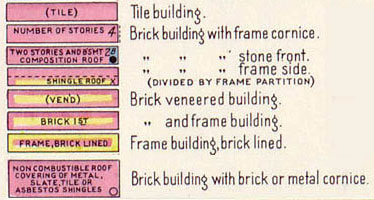
Color plays an important role in Sanborn map reading. In Example 1, we see that brick and tile are represented with a reddish/pink color. Several advantages demonstrate themselves when using color: a) the mapmaker can easily and quickly convey information; b) space formerly used to convey this information can now be used to convey more detailed information; and c) uniformity across all the maps is achieved and maintained.
Picture
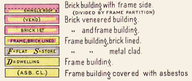
The use of yellow indicates frame, or wood, structures. Example 2 shows the use of framing on the inside as well as outside of buildings. Along with the color indicators, the map uses basic abbreviations to convey other information. S = store, D = dwelling, and ASB. CL. = asbestos clapboards.
Picture
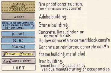
Other colors employed by Sanborn mapmakers included an olive green to demark fire resistive construction and gray for adobe construction material. Blue denotes concrete and cinder block construction. Gray is also used to indicate metal or iron building materials. The tenant indicator "loft" is shown in color to indicate that it can be seen in any of the construction color indicators.
Picture
To print an image with many of the colors and symbols, click here.

Sanborn Keys, Legends, and Symbol Sheets

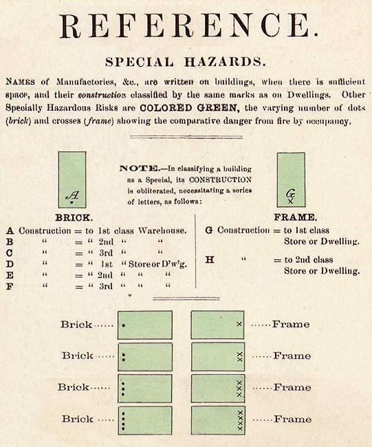
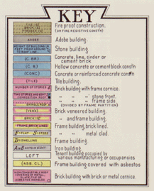
Fire insurance maps are distinctive because of the sophisticated set of symbols that allows complex information to be conveyed clearly. In working with insurance maps, it is important to remember that they were made for a very specific use, and that although they are now valuable for a variety of purposes, the initial selection of information to be mapped and the way that information was portrayed was dictated by the needs of the insurance industry.
Picture
The prefatory material found at the beginning of atlases and on the first sheet of smaller editions usually included a legend or "key" to symbols. Knowledge of these is essential to proper interpretation of the information found in fire insurance maps. The use of these symbols on fire insurance maps, especially those done by the Sanborn Map Company, was prescribed by company manuals and can usually be interpreted with a considerable degree of confidence. However, the symbols, abbreviations, and annotations are not always easily interpreted. Therefore, it is important for researchers to consult the keys to symbols. It is also important to remember that over time new symbols were added and that there were variations in the way in which symbols were applied.

​Title Pages

Most editions of fire insurance maps contained prefatory material that is useful or necessary for interpreting the maps and which now has historic value in its own right. In particular, the map indexes and the descriptions of a city's fire protection services of a city provide insights into various aspects of the development of urban America. The amount and nature of such introductory material varies widely from city to city and over time, reflecting changes in mapping policies of the Sanborn Map Company, the size of the city, and the rate of change within the city. The following discussion highlights major features of the prefatory material, but not all elements will necessarily be found in the fire insurance maps for a given city or town.
Small-town maps that comprised only a few map sheets were generally issued in loose-leaf format and did not have separate title pages. The first page of such editions, however, would include the names of the city, county, and state. The county name was important for differentiating towns of the same name within a state. It is important to note that because of divisions of counties or changes in county boundaries, a city may now be part of a county different from that in which it was originally mapped.
For large-city maps issued in one or more volumes, the title page often presents a visual delight of ornate typography and design. As cities became denser and larger over time, the Sanborn Map Company occasionally altered the presentation of the coverage of a city. A single volume could be divided: for instance, volume 1 from an edition in the late 1800s might become volume 1, North and volume 1, South in the 1920s. Also, the coverage of the suburban portions of a city could be shifted from volume to volume. Researchers need to be aware of such changes reflected in the titles to insure that they are using the volume that covers the portion of the city in which they are interested.
An important component of title pages for large city atlases is the listing of incorporated and unincorporated places covered in the volume. This is particularly common on the fringe areas of towns from the 1920s onward, where suburban developments and new additions to the territory of a city were frequently given their own names in local usage. Such place names have been listed in the index of Fire Insurance Maps in the Library of Congress. These names can also be searched through the search engine available on the Library of Congress Web site.

​Reports on Fire Protection, Services and Infrastructure
Picture
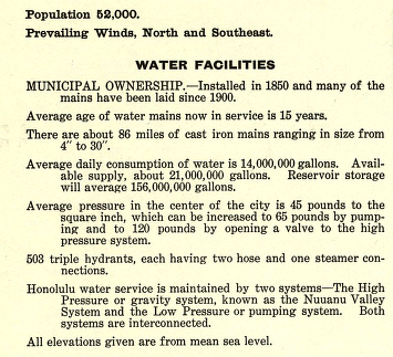
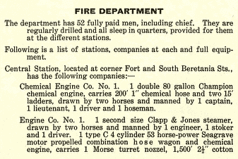
To the insurance industry, a valuable component of the prefatory material was a description of the fire-fighting equipment and water system of a city or town. The description could be a simple statement of a line or two in the coverage of a small town, or an elaborate report of many paragraphs for the larger cities. Reports would address such issues as the number and types of fire-fighting equipment and the number and training background of firefighters. The size, extent, and pressure of water mains was a critical factor that was often addressed in such reports. The predominant wind patterns were usually noted as well.

Interpreting Scale

The vast majority of fire insurance maps were drawn at a scale of one inch to fifty feet (1:600) when expressed as a representative fraction. A smaller or less detailed scale of mapping was employed for suburban areas or large industrial sites. For these areas, scales of one inch to one hundred feet (1:1,200) or one inch to two hundred feet (1:4,800) were used. In rare instances, even smaller scales were used. Most map sheets contain a bar scale that facilitates the measurement of features or distances, and the scale is usually given in the title of the map as well.

Interpreting Sheet Numbers

Considering that there were more than fifty thousand editions of fire insurance maps of more than ten thousand communities, it is not surprising to find inconsistencies in the way sheets in a given edition were numbered. In early atlases, numbering was often sequential across coverage for the whole city. In other cases, especially in later editions, numbering was sequential within each volume. In some early editions also, double-page plates were given a single number, but the most common pattern was to have a separate number for each page. Prefatory material was not given page numbers, however.
In the list of maps, Fire Insurance Maps in the Library of Congress, the figure in the column that indicates the number of pages does not reflect the page numbering. The figure that is given includes any unpaginated prefatory material, even the inside of atlas covers to which indexes have been pasted. Where applicable, the comments column in Fire Insurance Maps in the Library of Congress indicates special numbering sequences, such as double-page plates.

Interpreting Sanborn Indexes

Graphic Index (or Key Map)
For researchers, an important part of the prefatory material is the graphic index that portrays the areas of the city covered by each sheet in the edition. In the case of multi-volume editions, there is often a "Graphic Map of Volumes" that shows the portions of the city covered by each volume.
The graphic index is frequently referred to as a "key map." When a researcher wishes to examine the coverage for a portion of a city, the graphic index is more useful than the street or other indexes. Key maps serve two purposes: they show the areas encompassed by individual sheets and indicate the portions of a city or town that were mapped. Coloring was generally used on key maps to indicate the area covered by an individual sheet in the edition or atlas. There are usually compass roses, often highly decorative, to orient the user, but not always scales.

Street Indexes
Picture
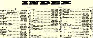
One important component of a fire insurance map or atlas is the street index. In theory, street indexes are rather simple. Street names are listed alphabetically, including numbered streets and avenues, which are spelled out in full. Subheadings under the name of a street frequently indicate address ranges covered by individual sheets in the edition or volume. For some large editions and atlases, however, this index may also contain a separate listing for a special component of the city, such as wharves and piers. In using these indexes, it must be remembered that street names and building numbering systems could change several times in a given city during the century and a half in which these maps were prepared. Trying to find the historical equivalent of a current address can be rather difficult if researchers try to rely strictly on the street indexes. In many cases, it will be necessary to relate an address on a current map to the key map described in the previous section. On the other hand, when working only with a written record of an address, street indexes are essential for locating buildings for which the street or number has changed.

Special Indexes
Picture
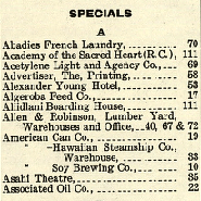
An interesting look at the life of a city can be found in an index of specific properties that sometimes appears separately but may also be a continuation of the street index. The name of this index usually includes the word "Specials." It identified major businesses, public buildings, factories, or other large structures. Such indexes were prepared to facilitate quick location of these major features. For current researchers, however, the list of "specials" is the equivalent of an abridged city directory that provides insight into the economic and social landscape of a community. From one edition of a city to another, entries in these indexes will come and go, and a particular business or institution will change its name to reflect new owners, a new function, or a modernized sense of propriety.

​Line Style, Abbreviations & Modern Symbols

Line Style
Much information could be conveyed through line types. A solid line indicated a solid wall. A break in a line showed doorways and other passages. Additionally, dashed lines could indicate some aspect of wall construction or the presence of a mansard roof. Extending solid lines beyond the edge of a building was a technique for indicating how high above the roof fire walls were built. When interpreting any fire insurance map, researchers should take care to consult the legend for that particular edition to ensure the correct interpretation of line symbiology.

Abbreviations
Fire insurance maps often relied on abbreviations to convey the type of activity that took place in a structure, since that information had some bearing on the likelihood of fires. The most common abbreviations are as follows: "D" or "Dwg" for a dwelling, "F" for a flat or apartment, "S" for a store, "Sal" for a saloon. Other abbreviations added more information about a structure: numerals were used to indicate the number of stories in a building, and the letter "B" indicated the presence of a basement. These could be combined, so that "2B," for instance, indicates that a building has two stories and a basement. Multiple symbols for a single structure could reflect the use or nature of different parts of a building; hence a two-story building with a basement might be marked "2B" for the main portion of the structure while an addition on the front had the number "1" by itself to indicate a single story.

In some instances, symbols and abbreviations were combined with text to describe a specific use. These can be frequently difficult to interpret because they are run together; the symbols for store and basement, for instance, can be combined in the form SinB, representing the phrase "store in basement."

Modern Symbols for Fire Insurance Maps
The symbolization used on fire insurance maps evolved over time as a result of such factors as the consolidation of the industry under the control of the Sanborn Map Company, the development and improvements of building codes, the development of larger and taller buildings that required notation of special features, and the maturation of this form of cartographic endeavor. To aid researchers in using these maps, a series of keys or legends have been reproduced from reference manuals that the Sanborn Map Company produced for its employees. Researchers, should not rely solely on the extensive legends reproduced here, however, the legends published in the atlases and on the small editions issued as loose sheets represent the use of symbols at the time the map was made.

Interpreting Congested District or Business District Maps

A valuable feature in the prefatory material of editions for large cities is the map of the "congested" or "business" district. This kind of map was drawn at scales intermediate between the large scale of a single sheet and the small scale of the key map for a volume. A typical map of this type might cover an area twenty blocks by thirty blocks in size. Generally, such maps served as a frame of reference for understanding the relationship of buildings and places in the heavily developed portions of towns. In some cases, they were annotated to show the limits of coverage by fire departments (in the early years of fire protection, fire company service was not provided to all parts of a town or city) or some other salient feature of the city.

Interpreting Dates

Publication Dates
For the first half century of fire insurance mapping, the dating of editions is generally straightforward. For small-town maps issued in loose-leaf format, the first page and generally each subsequent page carried the month and year of publication quite prominently in an upper corner of the map. The year of publication was usually repeated as part of the copyright notice that appeared as part of or adjacent to the title.

The dating of multi-volume editions of large-city maps is somewhat more complicated. The date on the first volume may be valid only for that particular volume, as the subsequent volumes may have been issued over a period of years. In several cases, a single volume within a multi-volume set was revised and reissued with a new date even before the whole edition was completed. In Fire Insurance Maps in the Library of Congress, therefore, date ranges are given for the coverage of multi-volume editions.

Corrected Editions
Beginning around 1920, the dating of an edition becomes rather complicated. In response to various economic factors around that time, the Sanborn Map Company began updating maps for its customers by issuing paste-on correction slips. These were generally applied by a company employee, who then annotated a chart, usually entitled "Correction Record," attached to the title page, recording the dates on which corrections had been applied. Such correction slips were intended to keep the map coverages current. Over the years, however, more and more correction slips were added, and it is impossible to determine which correction slips were applied in which years. For many cities, as many as fifty or sixty series of correction slips were applied over the course of thirty or forty years. In Fire Insurance Maps in the Library of Congress, the dates for such editions are the date of the original printed edition of the map and the latest date for which corrections were applied.

The latest date, however, is not always found in the "Correction Record." In many cases, additions to indexes pasted into an atlas are later than the last correction slip annotation indicates. In Fire Insurance Maps in the Library of Congress, the latest date of an edition or volume reflects the latest date found on any material pasted into that volume or edition.

The vast majority of examples of paste-on correction sheets in the collections of the Library of Congress come from the maps produced by the Sanborn Map Company from the late 1920s. This technique, however, appeared very early in the history of fire insurance mapping. When significant changes took place in a city, it was important to update the fire insurance plans. In some cases, the amount of change did not warrant mapping the entire city again. In other cases, it may have been prudent to update certain key changes even before the whole city could be re-mapped. To accomplish this, fire insurance map producers printed a correction sheet that was pasted over the incorrect information. Charles Rascher, for example, in his 1891 atlas of Chicago, includes seven different updates printed on a single sheet. Where a map producer had inventory in stock, the corrections could be applied before the volume was sold. At least some companies offered the service of sending employees to customers' offices, where the correction sheets could be applied on site.

​Interpreting Water System Maps

Picture
In many editions of fire insurance atlases of large towns or cities, there was a separate map, frequently an inset but sometimes rather substantial in size, showing the water distribution system. Such a map might be accompanied by a description of pumping station equipment, pressure, sizes of mains and water lines, the types and distribution of fire hydrants, and so forth.
Contact
© COPYRIGHT Vintage Bentonville 2018.
​ALL RIGHTS RESERVED.
  • Home
  • Businesses
    • E Central >
      • 102 E. Central - Downtown Bentonville Inc.
      • 104 E. Central - Bentonville Convention & Visitor Bureau
      • 106 E. Central - Brosh Trading Company Jewelers
      • 108 E. Central - Table Mesa Restaurant
      • 112- 114 E. Central - Bleachers & Central Ave Toys
      • 116 E. Central - Bloomhills Hair on the Square
      • 200 Block E. Central American Legion Hall
      • 202 E. Central - Tucker's Corner
      • 300 Block E. Central Bentonville Steam Laundry
    • W Central >
      • 101 W. Central - Peoples Bank / Bank of Bentonville
      • 105 W. Central - Scribner & Holland Attorneys
      • 107 W. Central - Horseshoe Cafe
      • 109 W. Central - Burgess Group
      • 111 W. Central - What's Ahead?
      • 112-114 W. Central - Benton County Hardware
      • 118 -120 W. Central - Blooms Gift Shop
      • 116 W. Central - Leuken / Craig Building
      • 113 W. Central - Three Dog Bakery
      • 115 W. Central Ave - Vacant
      • 117 W. Central - City Hall
      • 123 W. Central - Eagle Hotel
      • 123 W. Central - Massey Hotel
      • 126 W. Central - Plaza Theater
      • 155 W. Central - Benton County National Bank
    • N Main >
      • 101 - 103 N. Main St. - Terry Block Building
      • 105-107 N. Main - Walton 5 & 10 Museum
      • 109 N. Main
      • 111 N. Main - The Station Cafe
      • 113 N. Main St. - Blue Moon Market
      • 209-211-213 N. Main St. - County Vault Building
    • S Main >
      • 104 - 106 S. Main
      • 105 S. Main Whitlock Insurance Agency
      • 110 - 112 S. Main St. - First Security Bank
      • 116-118 S. Main
      • 124 S. Main St Ghiradelli Chocolate
      • 202 N. Main St. - Applegate's Pharmacy
      • 122 S. Main Lisa Kelley Law Office
      • 207 S. Main - Charles O. Mitchell & Co. - Marble Works
    • NE 2nd Street >
      • 101 N. E. 2nd St. - Cripps Law Office
      • 103 N.E. 2nd St. - Overstreet's Jewelry
      • 105 N. E. 2nd St. - Benton County Democrat Building
      • 107 N. E. 2nd St. - Arvest Bank Building
      • 113 / 115 N. E. 2nd St.
      • 200 Block N. E. 2nd St. - Macon & Carson's Distillery
    • SW A Street >
      • 100 Block S. W. A St. - Zesto / Dari-O
      • 104 S. W. A St. - Davidson DX
      • 406 S. W. A St. Wage's White Kitchen
      • 505 S.W. A St - Bentonville Canning Company
      • 709 S.W. A St. - Southside Grocery
      • 800 Block S. W. A St. Mellonville Fruit Stand
    • Lettered/Numbered Streets >
      • S. E. 3rd St. - Bentonville / Blocher Evaporator
      • 507 S.E. E St. - Kraft Plant
      • 514 S. E. 5th St. - Eagle Milling Co.
      • 508 S.W. 8th St. Jim's Feed Store
    • Everything Else >
      • Bentonville Casting Co.
      • Bentonville Livestock Auction
      • Bentonville Mills
      • City Blacksmith Shop
      • Eagle Mill
      • Park Springs
      • Rainbow Curve
      • Rainbow Drive In
      • The Original Bates Hospital - A Brief History
  • Churches
    • A Look at Bentonville Church History (1906)
    • Bentonville First Baptist Church
    • Cumberland Presbyterian Church
    • First Christian Church
    • First Methodist Church
  • Events
    • Civil War >
      • A Letter To Home!
      • Bentonville at the beginning of the Civil War
      • Bentonville and the Civil War
      • Confederate Reunion
      • Gen. Franz Seigel a Visitor
      • History of the Confederate Monument
      • Confederate Statue dedication
      • History Of A Great Monument
    • Crime-Robberies-Justice >
      • Bentonville Bank Robbery
      • Bentonville Bank Robbery Told By The Robber - Henry Starr
      • The Bentonville Bank Robbery of 1893
      • James Gang comes to town
      • It was a Great Day for a Hanging
      • Old sheriff only drew weapon once
      • Robbery of the Craig & Sons Store in Bentonville
      • The Hanging of Cornelius Hammon
      • The Courthouse Raid
    • Holidays-Festivals >
      • Bentonville Balloon Festival
      • Christmas On the Square
      • Remembering Sugar Creek Days
      • Ringling Bro. Circus Comes To Town
    • Fair & Agriculture >
      • The Big Red Apple Center - Bentonville
      • Benton County Fair / Fruit Fair
      • Bentonville Agriculture
      • Sorghum Making Time
      • Opportunities in Fruit Growing
      • Foster Meat Market
      • Science Fair of 1958
    • Sports >
      • Bentonville and Baseball
      • Horse Racing Track - 800 block S. W. 8th St.
      • Turkey Race
    • Bentonville Downtown >
      • A Look at Bentonville and its Businesses in 1906
      • Bentonville - The Prairie City of Northwest Arkansas (1883)
      • Downtown Bentonville in the 1880s and 1890s
      • Park in City Square a Beauty Spot Since 1880
      • Round the Square / Farmers Market
      • William Terry and the Terry Block Building
      • Weather Bureau in Bentonville Recalled
    • Dedications & Development >
      • A Bentonville Chronicle Of Ye Goode Olde Days
      • Bentonville - Remember The Past Plan For The Future
      • Building Boom of 1887 - 88
      • Dedication of Highway 72
    • Fires & Tragic Tales >
      • Early Morning Fire At Applegate's Pharmacy
      • Jail House Fire
      • Peel Mansion has it very own ghost
      • Downtown Bentonville Fire of 1961
  • Houses & Homes
    • 100-400 W Central >
      • 207 W. Central - Jackson House
      • 305 W. Central - Craig / Reeves Home
      • 307 W. Central - Craig / Bryan House
      • 400 S. Walton Blvd. - Peel Mansion
      • 405 W. Central - Flannery House
      • 407 W. Central - Vol Lindsey House
    • 500 Block W Central >
      • 501 W. Central - Duke House
      • 503 W. Central - David Peel House
      • 504 W. Central - Johncox House
      • 507 W. Central - Holmes / David W. Peel , Sr. House
      • 508 W. Central - Dave Peel House
    • 600 Block W Central >
      • 601 W. Central - Applegate / Scates House
      • 603 W. Central - Greer House
      • 602 W. Central - Lindsey House
      • 604 W. Central - Enfield House
      • 605 W. Central - Lincoln House
      • 606 W. Central - Linebarger House
      • 607 W. Central -Delong House
      • 608 W. Central - Pittman House
      • 610 W. Central - Marple House
    • 700 Block W Central
    • Other Noteworth Homes
  • Railroads
    • Proposed Bentonville Railroads
    • Coming of the Frisco
    • Bentonville Railroad Company
    • Bentonville Wanted The Railroad
    • Arkansas & Oklahoma Railroad
    • Bentonville Branch of the Frisco Railroad
    • End of "Gold Rush" Brought KCS into Benton County
    • Frisco Lines Active In Benton County Growth
    • Looking for an alternate Railroad Route
    • Interurban Railway - Arkansas Northwestern Railroad Company
    • History of Railroads in Benton County
    • Train Depots Of Benton County
  • People
    • A >
      • Ammons, William Edwin
      • Applegate, Joseph
      • Atkinson, Dr. Richard Matson
      • Arthur, John C.
    • B >
      • Baker, Zachariah (Uncle Zach)
      • Barney, Tompkins Coleman
      • Bates, Andrew Jackson
      • Beasley, Judge Joseph (Joe)
      • Beasley, Sam
      • Berry, Senator James H.
      • Black, Gary Dale
      • Black, Hugh "Tater"
      • Black, John Max
      • Black, John
      • Black, J Dickson
      • Blake, Thomas
      • Brown, Charles
      • Bryan, Joseph
      • Burks, Bennette T.
      • Burks, W. A. (William Arthur)
      • Bundy, M. A.
      • Burns, John H. & James P.
    • C >
      • Cargile, Charles H., M. D.
      • Carnahan, Rev. Peter
      • Clark, William R.
      • Coberly, Terry (Black)
      • Covey, Joseph Dow
      • Craig, James Terrill
      • Cross, Harvey Lamar
    • D >
      • Davis, Goldsmith Chandler
      • Davis, Dr. William
      • Deming, William B.
      • Dickerson, Arthur "Rabbit"
      • Dickson, John Alvin
      • Dickson, Joseph S.
      • Dinsmore, Alexander Winchester
      • Dinsmore, Hugh Anderson
      • Daniel Douglas - FBI / U. S. Marshal
      • Douglas, Fred
      • Douglas, Hal Cooper
      • Douglas, Marion
      • Dunn, Benjamin F.
    • E-G >
      • Enfield, Judge William (Bill)
      • Elliott, Hon. Samuel N.
      • Floyd, W. S. (William)
      • Foster, David (Uncle Dave) S.
      • Gailey came to Bentonville
      • Galbreaith, Franklin Pierce
      • Giger, Julius
      • Green, Elisha
      • Greenwood, Judge Alfred Burton
      • Gilmore, Isaac B.
    • H
    • J-L >
      • Jackson, George
      • Jackson, Nichols Springfield
      • King, Helen (Lewis)
      • Kohley, Charles Robert (Bob)
      • Knott, James C.
      • LeFors, Whitfield
      • Lincoln, George T.
      • Looney, Edgar
    • M >
      • Macon, Robert
      • Maples, George
      • Massey, Robert
      • Mauck, W. D. (William Dudley)
      • Maxwell, Dr. John Livingston
      • Maxwell, William Thomas
      • McAdams, John C.
      • McClinton, Joseph H.
      • McGill, J. T. (John Thomas)
      • McGill, Leonidas (Lon) Hogg
      • Mitchell, Charles O.
    • N-R >
      • Pace, Alonza "Lon"
      • Peel, David (Dave) Walker Jr.
      • Peel, David Walker Sr.
      • Peel, John W.
      • Peel, Samuel
      • Peel, Zillah Z. (Cross)
      • Rice, Charles Matlock
      • Rice, James A.
      • Russell, Andrew Jackson
    • S-T >
      • Seamster, Alvin (Ab)
      • Smartt, Alfred
      • Smart, Lewis
      • Smartt, Dr. John
      • Taliaferro, Dr. Charles Dickson
      • Terry, Col. William
      • Thaden, Louise
    • U-Z >
      • Walton, Sam
      • Woolsey, Henry B.
      • Wyatt, Dr. Thomas
  • Schools
    • Bentonville Academy
    • Bentonville Colored School
    • Early Bentonville Schools
    • Early Bentonville Public Schools
    • Hit and Miss Bentonville School History
    • Old High School - An Architectural Landmark
    • Old High
    • R. E. Baker
    • Thomas Jefferson Elementary
    • Rare Book Tells Story Of Bentonville College
  • Government Institutions
    • Benton County Poor Farm
    • 201 N. E. 2nd St. - Weather Bureau
    • 201 N. E. 2nd St. Post Office / Benton County Court
    • Benton County Courthouse History
    • Bentonville Fire Department
    • Benton County Formed In 1837, Shows Steady Growth Thru Years
    • Benton County Courthouses Before 1928
    • Benton County Courthouse
    • Benton County Jails
    • Bentonville Water Utilities
  • Yearbooks
    • Bentonville 1940s >
      • 1940 Bentonville Yearbook
      • 1943 Bentonville Yearbook
      • 1944 Bentonville Yearbook
      • 1946 Bentonville Yearbook
      • 1947 Bentonville Yearbook
      • 1948 Bentonville Yearbook
      • 1949 Bentonville Yearbook
    • Bentonville 1950s >
      • 1950 Bentonville Yearbook
      • 1951 Bentonville Yearbook
      • 1952 Bentonville Yearbook
      • 1953 Bentonville Yearbook
      • 1954 Bentonville Yearbook
      • 1955 Bentonville Yearbook
      • 1956 Bentonville Yearbook
      • 1957 Bentonville Yearbook
      • 1958 Bentonville Yearbook
      • 1959 Bentonville Yearbook
    • Bentonville 1960s >
      • 1960 Bentonville Yearbook
      • 1961 Bentonville Yearbook
      • 1961 Bentonville Yearbook
      • 1962 Bentonville Yearbook
      • 1963 Bentonville Yearbook
      • 1964 Bentonville Yearbook
      • 1965 Bentonville Yearbook
      • 1967 Bentonville Yearbook
      • 1968 Bentonville Yearbook
    • Near Bentonville >
      • 1946 Centerton Yearbook
      • 1947 Centerton Yearbook
      • 1950 Decatur Yearbook
      • 1914 Rogers Yearbook
      • 1924 Rogers Yearbook
  • Newspapers
    • Bentonville Newspapers
    • Sep 23, 1873 - The Weekly Advance
    • 1891 Jan-Mar >
      • Feb 6, 1891 - Bentonville Sun
      • Feb 13, 1891 - Bentonville Sun
      • Mar 07, 1891 - Bentonville Sun
      • Mar 14. 1891 - Bentonville Sun
      • Mar 21, 1891 - Bentonville Sun
      • Mar 28, 1891 - Bentonville Sun
    • 1891 Apr-Jun >
      • Apr 11, 1891 - Bentonville Sun
      • Apr 18, 1891 - Bentonville Sun
      • May 16, 1891 - Bentonville Sun
      • May 30, 1891 - Bentonville Sun
      • Jun 13, 1891 - Bentonville Sun
      • Jun 20, 1891 - Bentonville Sun
      • Jul 25, 1891- Bentonville Sun
    • 1891 Jul-Sep >
      • Jul 4, 1891 - Bentonville Sun
      • Jul 11, 1891 - Bentonville Sun
      • Jul 18, 1891 - Bentonville Sun
      • Aug 01, 1891 - Bentonville Sun
      • Aug 8, 1891 - Bentonville Sun
      • Aug 15, 1891 - Bentonville Sun
      • Sep 05, 1891 - Bentonville Sun
      • Sep 19, 1891 - Bentonville Sun
    • 1891 Oct-Dec >
      • Oct 3, 1891 - Bentonville Sun
      • Oct 10, 1891 - Bentonville Sun
      • Oct 17, 1891 - Bentonville Sun
      • Oct 24, 1891 - Bentonville Sun
      • Nov 07, 1891 - Bentonville Sun
      • Nov 14, 1891 - Bentonville Sun
      • Nov 28, 1891 - Bentonville Sun
      • Dec 05, 1891 - Bentonville Sun
      • Dec 12, 1891 - Bentonville Sun
    • 1892 Jan-Feb >
      • Jan 02, 1892 -Bentonville Sun
      • Jan 09, 1892 - Bentonville Sun
      • Jan 16, 1892 - Bentonville Sun
      • Jan 23, 1892 - Bentonville Sun
      • Jan 30, 1892 -Bentonville Sun
      • Feb 20, 1892-Bentonville Sun
      • Feb 27, 1892 - Bentonville Sun
    • 1892 Mar-Dec >
      • Mar 05, 1892 - Bentonville Sun
      • Mar 12, 1892 - Bentonville Sun
      • Mar 19, 1892 - Bentonville Sun
      • Mar 26, 1892 - Bentonville Sun
      • Sep 10, 1892 - Bentonville Sun
    • 1893 Jan-Mar >
      • Jan 09, 1893 - Bentonville Sun
      • Feb 25, 1893 - Bentonville Sun
      • Mar 04, 1893 - Bentonville Sun
      • Mar 11, 1893 - Bentonville Sun
      • Mar 18, 1893 - Bentonville Sun
      • Mar 25, 1893 - Bentonville Sun
    • 1893 Apr-Jun >
      • Apr 01, 1893 - Bentonville Sun
      • Apr 08, 1893 - Bentonville Sun
      • Apr 15, 1893 - Bentonville Sun
      • Apr 22, 1893 - Bentonville Sun
      • Apr 29, 1893 - Bentonville Sun
      • May 6, 1893 - Bentonville Sun
      • May 13, 1893 - Bentonville Sun
      • May 20, 1893 - Bentonville Sun
      • Jun 03, 1893 - Bentonville Sun
      • Jun 17, 1893 - Bentonville Sun (Bentonville Bank Robbery)
      • Jun 24, 1893 - Bentonville Sun
      • Jul 1, 1893 - Bentonville Sun
    • 1893 Jul-Sep >
      • Jul 08, 1893 - Bentonville Sun
      • Jul 15, 1893 - Bentonville Sun
      • Jul 22, 1893 - Bentonville Sun
      • Jul 29, 1893 - Bentonville Sun
      • Aug 5, 1893 - Bentonville Sun
      • Aug 12, 1893 - Bentonville Sun
      • Aug 19, 1893 - Bentonville Sun
      • Aug 26, 1893 - Bentonville Sun
      • Sep 2, 1893 - Bentonville Sun
      • Sep 09, 1893 - Bentonville Sun
      • Sep 23, 1893 - Bentonville Sun 1893
      • Sep 30, 1893 - Bentonville Sun
    • 1983 Oct-Dec >
      • Oct 7, 1893 - Bentonville Sun (Civil War Reunion)
      • Oct 14, 1893 - Bentonville Sun (Civil War Reunion)
      • Oct 21, 1893 - Bentonville Sun
      • Oct 28, 1893 - Bentonville Sun
      • Nov 4, 1893 - Bentonville Sun
      • Nov 18, 1893 - Bentonville Sun
      • Nov 25, 1893 - Bentonville Sun
      • Dec 02, 1893 - Bentonville Sun
      • Dec 09, 1893 - Bentonville Sun
      • Dec 16, 1893 - Bentonville Sun
      • Dec 30, 1893 - Bentonville Sun
    • 1894 Jan-Mar >
      • Jan 13, 1894 - Bentonville Sun
      • Jan 20, 1894 - Bentonville Sun
      • Jan 27, 1894 - Bentonville Sun
      • Feb 03, 1894 - Bentonville Sun
      • Feb 10, 1894 - Bentonville Sun
      • Feb 17, 1894 - Bentonville Sun
      • Feb 24, 1894 - Bentonville Sun
      • Mar 03, 1894 - Bentonville Sun
      • Mar 10, 1894 - Bentonville Sun
      • Mar 24, 1894 - Bentonville Sun
      • Mar 31, 1894 - Bentonville Sun
    • 1894 Apr-Jun >
      • Apr 07, 1894 - Bentonville Sun
      • Apr 14, 1894 - Bentonville Sun
      • Apr 21, 1894 - Bentonville Sun
      • Apr 28, 1894 - Bentonville Sun
      • May 05, 1894 - Bentonville Sun
      • May 12, 1894 - Bentonville Sun
      • May 19, 1894 - Bentonville Sun
      • May 26, 1894 - Bentonville Sun
      • Jun 2, 1894 - Bentonville Sun
  • Maps
    • Bentonville Sanborn >
      • Reading Sanborn Maps
      • Bentonville 1886 Sanborn Magnified
      • Sanborn 1886 Google Overlay
      • Sanborn 1892 Google Overlay
      • Bentonville 1892 Sanborn Map
      • Bentonville 1897 Sanborn Map
      • Bentonville 1903 Google Overlay
      • Sanborn 1904 Google Overlay
      • Bentonville 1904 Sanborn Map
      • Bentonville 1908 Sanborn Map
      • Bentonville 1914 Sanborn Map
      • Bentonville 1922 Sanborn Map
    • Bentonville Other >
      • Bentonville City Map (Circa 1962)
      • Bentonville Plat Maps - Arkansas
      • Bentonville City Map (Cira 1962)
      • Bentonville City Highway Map
      • 1974 Topics Study
      • Ozark Highway thru Bentonville
      • Frisco Line Map
    • Benton Co >
      • Benton County 1891 Geological
      • Benton County Highway Map 1936
      • Benton County Highway Map 1948
      • Benton County Highway Map 1963
      • Benton County Highway Map 1969
    • Arkansas-Regional >
      • Arkansas Map (Circa. 1910)
      • Arkansas Map 1883
      • Arkansas Map Railroad 1897
      • Arkansas Map (Pre 1919)
      • Arkansas Map 1924
      • Arkansas Territory Map (Pre 1836)
      • Arkansas Map 1918
      • Geologic Map 1892 North Arkansas
      • Geologic Map 1892 North Arkansas 2
      • Geologic Map North Arkansas
      • NWA Topo
      • Highway System of Arkansas 1936
    • Indian Territorial >
      • Cherokee Nation Map 1903
      • Indian Territory Surveys Map 1902
      • Indian Territory Map 1883
      • Indian Territory Cessions Map 1909
      • Indian Territory Cession Map 1884
      • Indian Territory Survey 1898
    • National >
      • U.S. Colored Popualtion 1880
      • U.S. Geological Survey Map 1899
    • Benton Co Cities A-F >
      • Bella Vista Plat Map - Arkansas
      • Avoca Plat Maps - Arkansas
      • Bloomfield Plat Map
      • Cave Springs Plat Maps - Arkansas
      • Centerton Plat Maps - Arkansas
      • Decatur / Corner Springs Plat Maps
      • Decatur 1914 Sanborn Map
      • Electric Springs Plat Maps - Arkansas
      • Esculapia Springs Plat Map
      • Forest Park Plat Maps - Near Siloam
    • Benton Co Cities G-H >
      • Garfield Plat Map - Arkansas
      • Gentry Plat Maps - Arkansas
      • Gentry 1913 Sanborn Map
      • Gentry 1918 Sanborn Maps
      • Gravette Plat Maps - Arkansas
      • Gravette Plat Map
      • Gravette 1913 Sanborn Maps
      • Healing Springs Plat Maps - Arkansas
      • Highfill Plat Map - Arkansas
      • Hiwasse Plat Maps - Arkansas
    • Benton Co Cities I-P >
      • La Rue Plat Maps - Arkansas
      • Lowell Plat Maps - Arkansas
      • Maysville Plat Maps - Arkansas
      • Monte Ne Plat Maps - Arkansas
      • Monte Ne Plat Map
      • Monte Ne Plat Map 2
      • Pea Ridge Plat Maps - Arkansas
    • Benton Co Cities R >
      • River Cliff Farm Plat Maps - Arkansas
      • Rogers Plat Maps - Arkansas
      • Rogers 1896 Sanborn Maps
      • Rogers 1901 Sanborn Maps
      • Rogers 1908 Sanborn Maps
      • Rogers 1914 Sanborn Maps
      • Rogers City Map (Pre 1968)
      • Rome City Plat Map - Arkansas
      • Roots Playground Plat Mat
    • Benton Co Cities S-Z >
      • Siloam Springs / Hico Plat Map - Arkansas
      • Siloam Springs 1897 Sanborn Maps
      • Siloam Springs 1904 Sanborn Map
      • Siloam Springs 1908 Sanborn Map
      • Siloam Springs 1914 Sanborn Map
      • Siloam Springs 1922 Sanborn Map
      • Springtown Plat Maps - Arkansas
      • Sulphur Springs Plat Maps - Arkansas
      • Sulphur Springs 1918 Sanborn Map
      • Sulphur Springs 1909 Sanborn Map
      • War Eagle Plat Maps - Arkansas
    • Cemetary Plot Maps >
      • Phillip's Cemetery Plat Map- Benton Co. -Arkansas
      • Ruddick Cemetery Plat Map - Benton County - Arkansas
  • History Books
    • Arkansas National Defense Industries Brochure
    • Jeff Davis Arkansas Governor Obit Book
    • The Ozark Mountain Region of Missouri and Arkansas KCS
    • The Western Boundry of Arkansas
  • Bentonville Then & Now
  • Videos and Presentations
  • About
  • Donate
  • Contact